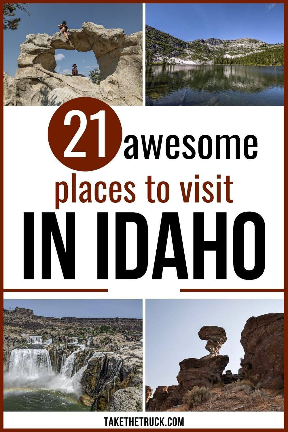
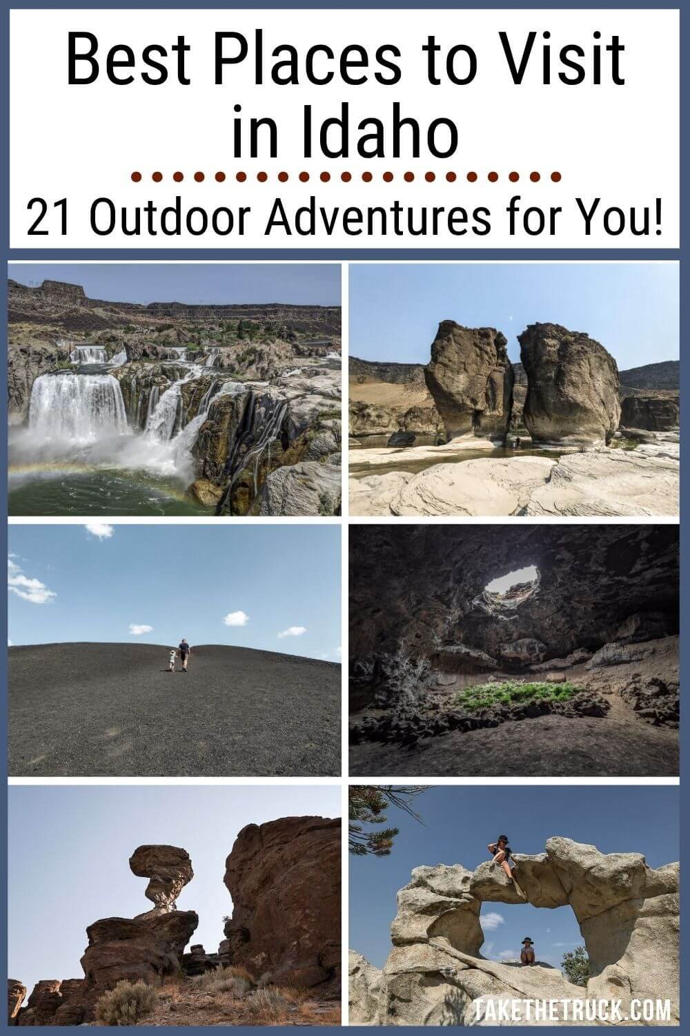
The 21 Best Places to Visit in Idaho

Prior to our first visit to Idaho, we literally thought of Idaho simply as the potato state. That’s all. Man were we wrong! There are so many more places to visit and fun things to do in this gorgeous and diverse state.
In fact, the number of places to visit in Idaho goes on and on! We spent an entire month exploring the state of Idaho - between seeing North America’s deepest canyon, the rich Native American, pioneer, and mining histories, seeing the Niagara Falls of the west, exploring more alpine lakes than we can count, access to unparalleled snow skiing, relaxing in numerous natural hot springs, exploring unspoiled caves formed by lava flows, admiring unique hoodoos and other unique geological formations, rugged landscapes and mountain ranges - there is no shortage of adventure to find in Idaho.
So to help you narrow down your list of places to visit in Idaho we’ve outlined the top 21 places to visit and so awesome things to do throughout the beautiful state of Idaho!
The Best Places to Visit in Northern Idaho
Roman Nose Lakes
GPS: 48.63505683713306, -116.57118099844897
Roman Nose Lakes are a bit of an adventure to get to, but should definitely make your list of places to visit in Idaho if you’re up in the panhandle!
The road in is a long gravel drive up the mountain with some washboard sections and occasional ruts and potholes, but most vehicles should be able to handle the drive with no problem. Be sure to take the Snow Creek route in (which is the way the GPS coordinates above should route you), arriving from the east/north east.
There’s a pit toilet at the trailhead and parking lot, which is right next to the lowest lake. Boardwalks around sections of this lake make for easy exploring before you hit the trail!

The Roman Nose Lakes Trail is about 4 miles out and back - more if you go off trail to explore around the middle and upper lakes - with a total of 725 feet of elevation change.
The views around each new bend are breathtaking and rival some of the best loved trails at the most popular national parks. But because this isn’t exactly convenient to get to, you won’t have to fight any crowds!
There are free primitive camping sites for trucks, cars, vans, or even RVs within walking distance to the lower lake. Several spots have fire pits, level pads for tents, and, with use of a cell phone booster, moderately workable wifi.
Weir Creek Hot Springs
Weir Creek Hot Springs is a great place to visit in Idaho! To get to the natural hot spring, park at the Weir Creek Trailhead immediately off the north side of Hwy 12, then follow the hiking trail approximately ½ mile to the springs.
The trail is established with only a small amount of elevation gain, but it does hug a steep hillside and is narrow at points, so make sure to keep little ones close by. You’ll pass several primitive campsites along the trail for tent campers and backpackers.

Weir Creek Hot Springs has 3 pool choices, and is great for visiting as a family.
The small upper-most pool stays at a consistent depth and was most hot tub-like in temperature; it was just big enough and most comfortable for our family of 3.
The middle pool of Weir Creek Hot Springs is the largest and most prominent - it was also the hottest of the three pools. This pool does have a PVC pipe installed in the man-made retaining wall that allows you to drain & lower the water level, but there is no cold water flowing into the pool to regulate the temperature.
The lower pool is a bit more challenging to access, as it requires a climb down the steep hillside to its location on the far side of the springs along Weir Creek. However it does mix with the cold creek water making it a more mild bath-water type temperature - though it is a bit more “swampy” than the other pools.
Idaho Beach Day Near Riggins
GPS: 45°24'01.5"N 116°12'51.8"W
If you’re taking a road trip through Idaho in the summer, this “beach day” along the Salmon River near Riggins is a great place to visit while driving through northern Idaho.
From Riggins, leave US Rte 95/Main Street, and head east on NF-1614/Salmon River Road, which parallels the Salmon River.
If you have a bigger RV, you might want to stop at the free camping area you’ll soon see on your left. It’s a very large gravel parking lot with provided pit toilets, right between the road and the river. Although it does seem to be a pretty popular place for RVers to land, there should be enough room to spread out.
If you’re in a truck bed camper, car, suv, or van, keep going! Cross the steel bridge and immediately hang a left onto the dirt road that parallels the north side of the Salmon River.
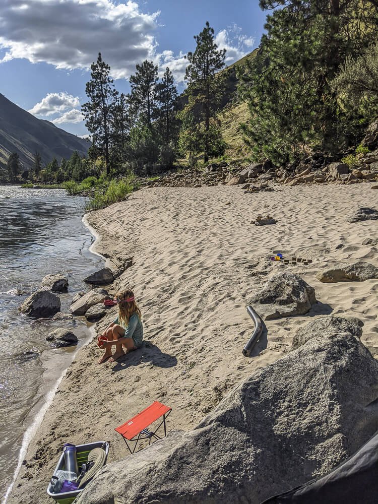
We found a free campsite off this road with shade, a sandbar, and wild huckleberries, and enjoyed a few days to rest and play.
Between the views of the river, the backdrop of the mountains, the sounds of the water, the seclusion, and the sand, it makes a great spot to reset as you gear up for more places to visit in Idaho!
For More Free Camping in Idaho - many sites that are along this route!: Free Camping in Idaho: 22 Awesome Dispersed Camping Spots
Heaven’s Gate Lookout
GPS Coordinates: 45.37010016199879, -116.49773965911854
The short hike to the Heaven’s Gate fire watchtower is a great place to visit in Idaho, and only about an hour west of Riggins, ID. Once you make the long drive up, and then hike up a little more, you’ll be rewarded with panoramic views overlooking 4 different states!
To get to Heaven’s Gate from Riggins, head south out of town on ID-95 for about a mile, then turn right (west) onto FS-517/Squaw Creek Road/7 Devils Road. 7 Devils Road is primarily a one lane gravel road with some steep and windy spots, including multiple switchbacks. Translation: Not recommended for RVs or those pulling trailers!
You’ll be on this road for about 18 miles, passing both Seven Devils and Windy Saddle Campgrounds about a mile before arriving at Heaven’s Gate.
Although the hiking trail is less than a mile round trip, it can still feel challenging if you aren’t used to hiking at higher elevations, as Heaven’s Gate Lookout sits at about 8,400ft. There is a pit toilet in the parking lot if needed.
The trail is closed much of the year so be sure to check with the local ranger station before heading up! It’s typically open from July to October.
For More Info: Forest Service Site about Heaven’s Gate Lookout
Hell’s Canyon National Recreation Area
GPS Coordinates: 45.24170574180976, -116.70097821749268
A visit to Hell’s Canyon should make your list of places to visit in Idaho - this little-known area of the country is home to North America’s deepest river gorge!
To get to Hell’s Canyon, we headed west out of Council, Idaho and spent quite a bit of time navigating Forest Service Roads through the Cuddy Mountain area - many of which weren’t on Google Maps. We dropped down into Hell’s Canyon on Kleinschmidt Grde/NF Dev Rd 050. So if you want to take this scenic route, be sure to have detailed paper maps or downloaded maps of the area as well as decent navigational skills - the reward is worth it, but this route is not recommended for those with RVs or pulling trailers.
If you aren’t up for that kind of adventure but do want to get into Hell’s Canyon, travel north out of Copperfield, Oregon, using the GPS coordinates above. Follow those directions, weaving back and forth between Idaho and Oregon along the Snake River.
This route, going from Copperfield to the Hell’s Canyon Dam, is a side trip of the Hell’s Canyon Scenic Byway. It’s a 22 mile long paved but narrow two lane road that winds its way along the Snake River, often hugging the towering basalt cliffs along the way.
Start with a full tank of gas and take your time to enjoy all the views!

Looking for more things to do in Idaho as you travel through Hell’s Canyon National Recreation Area?
This Recreational Area encompasses over 650,000 acres of wilderness. Fishing, horseback riding, hiking, enjoying vista points, viewing artifacts from prehistoric tribes and remnants from the mining era, camping, whitewater boating, guided Snake River tours or guided tours of Hell’s Canyon Dam - there’s something for everyone!
For More Info: Forest Service Site on Hell’s Canyon Recreation Area
Trail Creek Hot Springs (also known as Samuel’s Hot Springs)
If taking a relaxing dip in hot springs is top of your list of things to do in Idaho, here’s another great one for you to visit!
Trail Creek Hot Springs is located about 20 miles northeast of Cascade, ID off NF-22/Warm Lake Rd, and has several nice pools large enough for a group of 6 to 8 people.
From Idaho Highway 55 turn east on NF-22/Warm Lake Rd (paved) and follow it approximately 20 miles northeast out of Cascade. The parking area is a large pull-out on the south side of the road.
From the parking area, you’ll see a trail that goes down the hillside towards the pools. The trail is steep and made of loose soil making it difficult to get down, but the climb back should be easier.

One of the nicest features of Trail Creek Hot Springs is the man-made piping system that allows you to adjust the pool temperatures by regulating the flow of cold creek water into the hot spring pools.
The pools are fairly shaded and secluded from one another. We did battle horseflies while visiting in the summer, so bring a flyswatter if you visit during this season!
There are no restrooms, cell service, or camping sites available at Trail Creek Hot Springs, but there are several primitive campsites with cell service available just off the highway as you get closer to Cascade heading back west on NF-22/Warm Lake Rd.
Goldbug Hot Springs
Goldbug Hot Springs is one of the most - if not THE most - beautiful and iconic Idaho natural hot spring. So it should definitely make your list of places to visit in Idaho!

Goldbug Hot Springs is nestled high up in the Sawtooth Mountains, and there are multiple pools sizes with various temperatures, hot & cold waterfalls, and spectacular views. And despite the somewhat strenuous 4 mile (round trip) hike and 1300ft elevation gain required to get there, it is very much worth the trek and one of our most recommended places to visit in Idaho!
To get there, head north through the town of Elk Bend, Idaho on Hwy 93, then turn east on Warm Springs Road. The road ends at the trailhead after about ¼ mile.
The trail actually starts on private property, making it super important that all visitors be respectful so that the trailhead remains open. After following the well established trail for 2 miles, you’ll be at Goldbug Hot Springs!
The first and last half-mile are the steepest and most strenuous, but our 4 year old was able to navigate the hike without too much difficulty. We highly recommend starting the hike early in the morning to avoid crowds and to keep from hiking in the full sun.
There is cell service at the hot springs, and there’s a pit toilet available at the trailhead.
The Best Places To Visit In Southern Idaho
Bayhorse Ghost Town
GPS Coordinates: 44.39777952586811, -114.31310137263482
If you’re into mining history and the old west, Bayhorse Ghost Town is a great place to visit in Idaho during your road trip!
It was first established in 1877 after a major lead-silver vein was discovered, and at its peak was home to around 300 people.
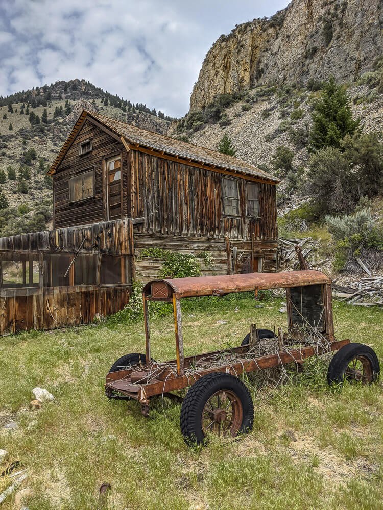
Bayhorse is on the National Register of Historic Places and is part of Idaho’s Land of the Yankee Fork State Park.
The well preserved ghost town can be explored using the self-guided tour with a detailed brochure walking you through the history of each remaining structure, and if you have questions there are several park rangers around the area to help. During our visit, there was a minimal entry fee.
For More Info: Idaho Parks & Rec Site on Bayhorse
Sacajawea Hot Springs
Sacajawea Hot Springs is made up of quite a few shallow rock-walled pools that crop out along the Payette River, surrounded by beautiful views of the river valley and the Sawtooth mountains that surround it.
During our visit, it was difficult to find a rocked-off pool that offered a comfortable temperature (some were way too hot and some too cold!), it was easy enough to move from pool to pool while exploring along the river. And since we were visiting during warm summer months, we ended up playing in the river with our daughter more than in the springs because of the inconsistent temperatures.
So although this wasn’t a relaxing hot spring soak as expected, it was still a memorable thing to do in Idaho!

To get to the springs from Lowman, head east on ID State Rt 21 (paved) for about 21 miles, before turning right onto Granjean Road. Stay on that for just over 5 miles.
There will be several pull-outs along the road that serve as the parking area and you’ll see Sacajawea Hot Springs from here. Pick one of the many trails that take you right down to the springs!
There are lots of primitive camping options nearby, and pit toilets are available at the Grandjean Campground. Though there was no cell service at the hot springs, we did have service at the end of Grandjean road near the turnoff on ID-21.
Rocky Canyon Hot Springs
Rocky Canyon Hot Springs is an incredibly beautiful place to visit in Idaho.
It’s located about 12 miles north of Crouch, Idaho off Middle Fork Road along the Middle Fork Payette River.
From the town of Crouch, follow Middle Fork Road (paved) north 12 miles. The road will turn to gravel for the last mile before arriving at the small parking area on the west side of the road. Once you park, you’ll be able to see Rocky Canyon Hot Springs across the river.
This unique natural spring is a beautiful cascade of water flowing from the mouth of the hot spring with several pool choices descending along the hillside of Rocky Canyon.

Because the mouth of the hot springs is located up the hillside from the river, there is no piping system to regulate the pools’ temperatures and the lowest pools along the riverside were the most bath-like in temperature.
Rocky Canyon Hot Springs is in full sun, and it’s best to plan your visit for summer or very early fall because you’ll have to wade across the river to get to the hot spring.
Little City of Rocks
GPS Coordinates: 43.119702267324385, -114.68314645917297
Little City of Rocks (near Gooding) and City of Rocks (near Almo) are two different places, although both have made our list of best places to visit in Idaho!
Little City of Rocks is a Wilderness Study Area managed by the BLM. This area is full of amazing rock formations including rock arches, hoodoos, and towers formed 8 million years ago by the settling of volcanic ash.

To get here from Gooding, head north on Hwy 46 for 12.5 miles. At that mile marker, keep your eyes out for the BLM sign marking the left-hand turn toward Little City of Rocks.
This dirt access road to Little City of Rocks is maintained by a private land owner. When rain creates muddy conditions or is in the forecast, a gate is closed near the entrance, but you can still park in a dirt lot near the highway and walk the road into Little City of Rocks (just a little over a mile). If the gate isn’t closed, just stay straight on the dirt road for 1.2 miles - not taking any of the left hand turns.
You’ll see a huge man-made rock wall at the dirt parking lot at Little City of Rocks. Park here and start your adventure!
There’s a roughly 4 mile loop trail that goes through the area. The first half of the trail is established and easy to follow, and many choose to simply go out and back, turning around when they lose the trail.
If you want to do the full loop be sure to download a trail map before arriving, and you’ll need basic navigational skills. There are also tons of small off shoots from the main trail that’ll help you explore some of the rock formations.
Primitive camping is allowed in Little City of Rocks, and wild camping from your vehicle is also fine in the parking lot by the man-made rock wall.
Bring plenty of water, even just for day hiking, and aways pack out your waste!
The best time of the year for visiting this area is early spring. It’ll resemble more of an oasis, with green plants and water flowing. In the summer, it gets hot quickly, and there’s very little shade here! Keep your eyes out for rattlesnakes too.
For More Info: Bureau of Land Management Site on Little City of Rocks
Tea Kettle Cave
GPS Coordinates: 42.9935233482179, -114.85397005982105
Tea Kettle Cave was one of our favorite places to visit in Idaho, and it’s one of those spots that sticks with you long after you leave. Because getting there isn’t exactly easy, we didn’t see anyone else exploring here and there are no man made features in place to help you explore the cave.
This cave has the perfect name. Imagine a tea kettle - like Mrs. Potts from Beauty and the Beast - with the lid removed. To get into the cave you climb down the “spout” and into the “pot”. Because the “lid” isn’t there, sunlight pours in, allowing bright green ferns to grow at the bottom of the cave.
Please watch your step, and stay out of the fern growth! Too much foot traffic will kill these plants, so tread lightly and be respectful.

You don’t need any special equipment to get into or out of the cave if you’re capable of a small amount of scrambling and/or sliding. We appreciated having head lamps but it could be done without them in mid-day.
You’ll need to have a high-clearance 4WD vehicle to get to Tea Kettle Cave (or plan to hike), and don’t plan to visit if there’s rain in the forecast. Follow the linked map above, plus here’s step-by-step directions so you can feel sure you’re on the right track!
From Gooding, head north out of town on S 1900 E / Hwy 46 for 4 miles. Turn left onto E 1400 S, which curves after a few miles and becomes S 1550 E. ½ mile after the 90 degree curve, turn left onto Dead Horse Cave Road.
Stay on Dead Horse Cave Road for 3.2 miles, and then turn left onto an unnamed road.
FYI: Dead Horse Cave is found at this turn - GPS Coordinates: 43.012225, -114.836122. This cave is really easy to access, is large enough to simply walk right into, and might be worth a stop if you enjoy caves. Sadly, the walls are covered in graffiti and people have left quite a bit of trash behind.
Continuing on to Tea Kettle Cave! This section will likely be slow going as you navigate the road, and at some point you may need 4WD. Some people opt to park at Dead Horse Cave and hike along the unnamed road that leads to Tea Kettle.
Whether you’re hiking or driving, you’ll be on the unnamed road for 1.8 miles. It finally connects with Canal Rd, and at that intersection you’ll find Tea Kettle Cave! Park, get out, and follow the GPS coordinates up the hill!
Thousand Springs State Park
GPS Coordinates: 42.86379178596395, -114.85102359178724
Thousand Springs State Park is made up of 7 different sections spread throughout the Hagerman Valley area and are all great places to visit in Idaho along the US 30 section of the Thousand Springs Scenic Byway (from Bliss to Twin Falls).
The 7 units are: Malad Gorge, Kelton Trail, Earl M. Hardy Box Canyon Springs Nature Preserve, Billingsley Creek, Ritter Island, Crystal Springs, and Niagara Springs. The headquarters are at Malad Gorge State Park near Tuttle.
Between these seven different units of 1,000 Springs State Park, there are so many things to do and places to visit in this part of Idaho!

You can view wagon ruts cut into stone from the Oregon Trail, see water dropping 250’ into Devil’s Washbowl, hike or paddle around Ritter Island in the Snake River and learn about pioneer history of the area, swim in (or just hike around!) one of the largest springs in North America, feel the spray from a spring-fed waterfall gushing out of a canyon wall at 250 cubic feet per second, enjoy fishing in well stocked lakes and streams, and hike numerous trails.
Many of these things can be seen as “roadside attractions”, where you pull up, hop out, and take in the view, but can also be explored more in depth by hiking on established trails.
For More Info: Idaho Parks & Rec Site on 1000 Springs State Park
Balanced Rock
GPS Coordinates: 42.54896488261278, -114.9576437543284
Balanced Rock is a quick roadside stop, and is a great place to visit in southern Idaho if you’re in the area. And if you’re looking for a reason to head this way, the free primitive Balanced Rock Campground is just a mile down the road and is well worth routing around!
You can pull off Balanced Rock Road / E 3700 N Road into a turnout to snap a photo of Balanced Rock, or you can get out and explore, hiking right up to it. It gets slightly challenging right up near the rock, but our 5 year old was able to do it with some pointers.

Balanced Rock is over 48’ tall and weighs 40 tons, while it’s pedestal that it balances on is only 3’ 17” wide. It’s definitely a cool thing to see in Idaho!
For More Info: Bureau of Land Management Site on Balanced Rock
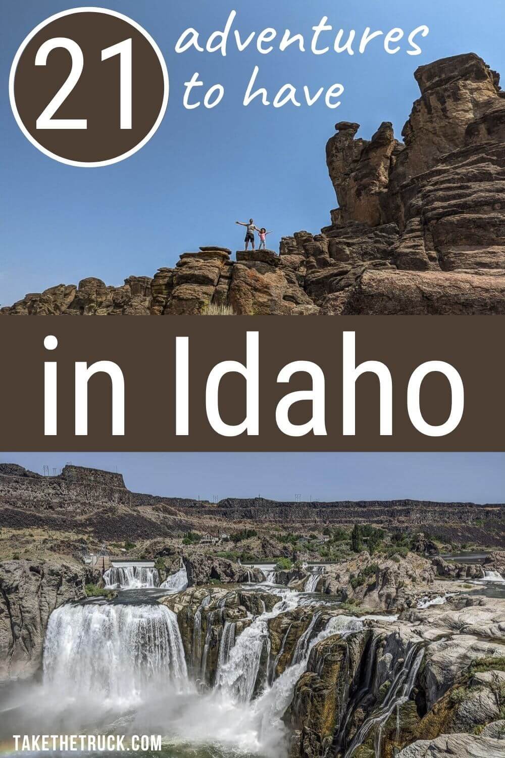
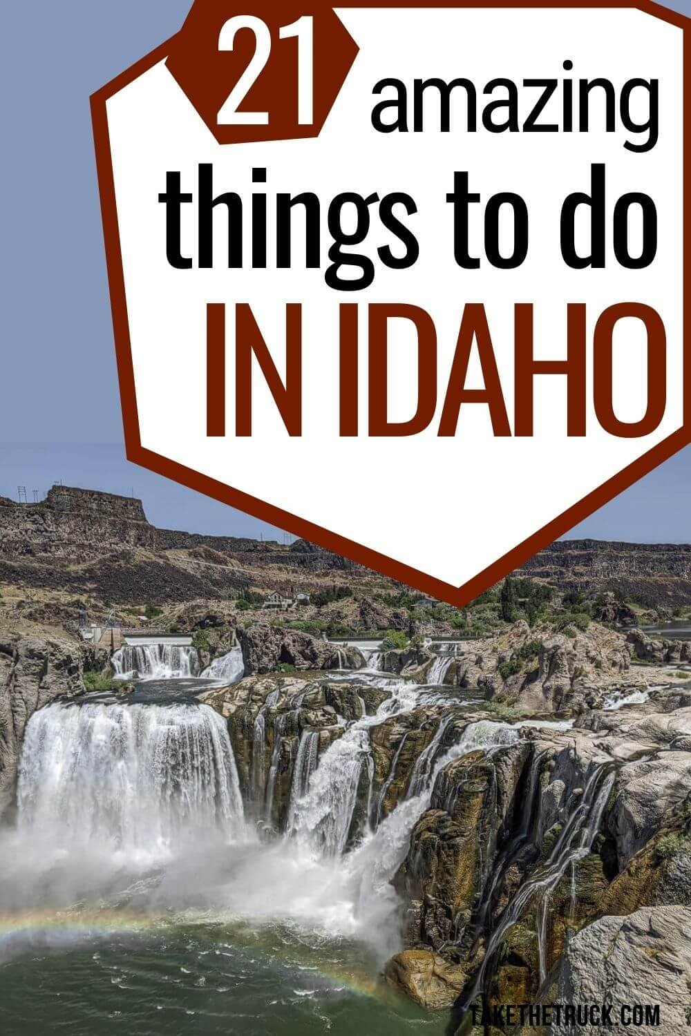
Shoshone Falls
GPS Coordinates: 42.596227928069666, -114.40083471199996
Shoshone Falls probably makes everyone’s list of places to visit in Idaho!
This waterfall is nicknamed the Niagara Falls of the west, and it's actually even taller than the real one at 212 feet! It’s located on the Snake River at the edge of Twin Falls.
The area is very popular and commercialized, with a small per vehicle entry fee. There are playgrounds, hiking trails, picnic areas, a boat ramp and swimming area, as well as a scenic overlook to take in Shoshone Falls.
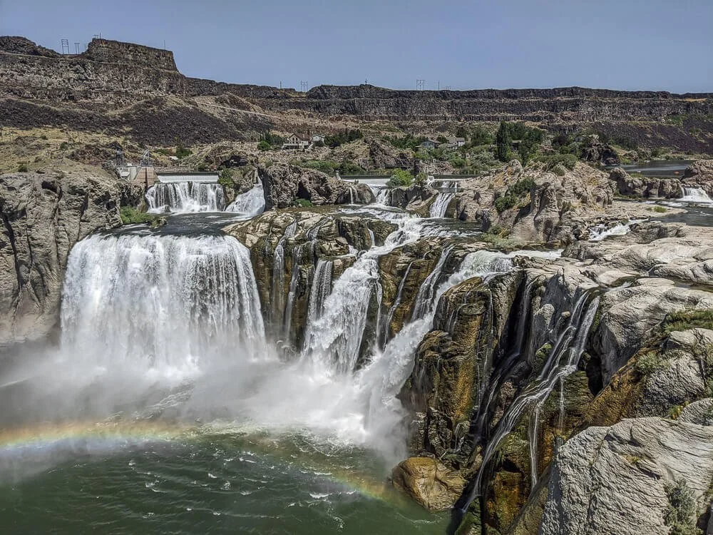
Be Warned: The water flow is controlled over this section of the Snake River! What this means is, 20 miles upstream from the falls at the Milner Dam, the water from the Snake River is often diverted, leaving only a trickle of water taking the 212 foot plunge. It’s super easy to check ahead though by viewing the live cams or looking up water flow information.
Even if water flow is low, if you find yourself near Twin Falls and looking for places to visit, the cliffs and surrounding scenery is still worth the stop.
For More Info: City of Twin Falls Site on Shoshone Falls
Web Cam: Click Here to View Shoshone Falls
Pillar Falls Hike in Twin Falls
Parking Lot GPS Coordinates: 42.591948946088344, -114.44043404384216
Trailhead GPS Coordinates: 42.59226488469519, -114.43464047249928
This short but steep 2 mile round trip hike in Twin Falls was one of our favorite places to visit in Idaho. The falls aren’t the most rewarding part of this hike - we’d describe them more as cascading drops rather than waterfalls. The real reward are the towering pillars and all the rock formations you can see and explore if the Snake River isn’t too high!

To get to the trailhead, use the above GPS Coordinates to guide you to a parking area at the corner of Eastland Dr. and Pole Line Rd. Then, rather than following the paved bike trail, you’ll walk along Pole Line Rd through a residential neighborhood for just over ¼ mile.
The trailhead for Pillar Falls will be on your left, off an old parking area plastered with “No Parking” signs, “Private Road” signs, and some pipes diverting water towards the Snake River.
The hike down is steep, with loose gravel, so be sure to wear shoes with good traction! The first part of the trail is maintained and extremely easy to follow. Once you’re closer to the river it does get a little trickier. At one point the trail Ys, with the more developed trail going off to the left. If you take a right at this Y, turning directly towards the pillars you can see in the Snake River, you’ll arrive sooner.
If you aren’t up for a hike, we heard that kayaking up to Pillar Falls is a great thing to do in Idaho! And if you don’t have one, you can rent one nearby and they can help you figure out all you need to know to kayak to Pillar Falls.
No matter if you hike or kayak, you won’t be able to miss the Perrine Bridge. It isn’t very often that a man made structure actually adds to the beauty of a place, but this is one of those times. Not only is the bridge a gem to look at, you’ll most likely catch quite a few base jumpers leaping off the bridge as you hike!
Cauldron Linn
GPS Coordinates: 42.496089, -114.132214
Another great place to visit in Idaho is Cauldron Linn Falls (also called Star Falls) on the Snake River.
We enjoyed it mostly because the surrounding area is less developed and still natural. The paths to the falls are dirt, there are no guardrails (don’t let your kiddos run ahead!), and you can wild camp for free right near the falls.

Some GPS programs will route you to the south side of the Snake River if you search for Cauldron Linn. Don’t follow those directions! You want to come in on the north side of the river to arrive at the coordinates given above.
If you enjoy kayaking or fly fishing, bring your gear! There’s great fly fishing upstream from the falls and kayaking downstream. The best time to visit is spring and summer when snow melt increases the amount of water pushing through this narrow gorge!
Craters of the Moon National Monument and Preserve
GPS Coordinates: 43.46194221588373, -113.5631912692541
Visiting Craters of the Moon National monument in Idaho is truly an otherworldly experience. There’s a huge concentration of volcanic landforms and structures within this zone of fractures and eruptions, many of which you can easily get to.

The most easily accessible way to explore the park is by driving the paved 7 mile loop road, jumping out to hike some trails, enjoy scenic overlooks, and explore inside caves and lava tubes. More adventure awaits in the park’s wilderness if time, weather, and your interest and energy level allow! During our time there in the peak of summer, we opted to forgo the extended hikes.
The best time of year to visit Craters of the Moon is in the fall because crowds thin and the weather is perfect for spending time outdoors.
The loop road is typically closed due to snow and ice from mid November to March. Wintertime visitors can enjoy snow skiing and snowshoeing.
Early springtime visitors should be sure to check ahead on the opening of the loop road because late snow storms often create closures even into May.
Wildflowers are at their peak in June. Summer gets hot, so if you’re visiting then, plan accordingly. Enjoy hiking early in the day, as there’s little shade, and plan to explore caves and lava tubes during the hottest part of the day.
Camping is available in Craters of the Moon, and free dispersed camping is pretty easy to find near the park.
For More Info: National Park Service Site on Craters of the Moon
Sawtooth National Recreation Area
GPS Coordinates: 43.81459253924924, -114.41554379347428
Sawtooth National Recreation Area is made up of over 750,000 acres in the National Forests about 2 hours north of Twin Falls.
Sawtooth National Recreation Area is an outdoor lover’s paradise, although, if you’re seeking solitude you’ll likely need to explore the backcountry away from the main roads, lakes, and trails. We were surprised by the number of people in the area, as well as by the developed feel of many of the main attractions.

That said, there are over 700 miles of trails, 40 mountain peaks that rise above 10,000 feet, and over 300 alpine lakes. So with just a little effort and enough time, it shouldn’t be too difficult to escape the crowds and enjoy some spectacular mountainous scenery and vistas on your own!
Tons of primitive camping is available throughout Sawtooth National Recreation Area, some reservable and some first come, first serve.
For More Info: Forest Service Site on Sawtooth Recreation Area
Museum of Clean
GPS Coordinates: 42.859934686419805, -112.44179428801506
The Museum of Clean is a fun and unique place to visit in Idaho if you are near Pocatello and looking for something to do indoors.
It’s not (strictly) a cleaning museum though (because why would we recommend a cleaning museum?!).
This place is centered around the idea that cleanliness affects all areas of life, and consists of 75,000 square feet of exhibits spread over multiple floors. The exhibits focus on not only keeping our physical space clean, but also on cleanliness of mind and body, caring for our Earth, clean water and air, and much more.

There are entire sections of the museum dedicated to kiddos with interactive displays and activities, so you should be able to find something for everyone!
For More Info: Museum of Clean Website
City of Rocks National Reserve
GPS Coordinates: 42.09344142268426, -113.63250749982451
City of Rocks National Reserve (not to be confused with Little City of Rocks near Gooding!) is in the southern-most part of the state near the Utah border, and it’s an awesome place to visit in Idaho. The closest town is Almo, which is where the visitor’s center is located.
Castle Rocks State Park is very similar, as it is adjacent to City of Rocks, but it does have a minimal daily vehicle entry fee.
However, City of Rocks National Reserve is free to enter and is open all year round, although winter weather may close access to some areas, so be sure to check ahead with the visitor’s center!

The reserve offers easily accessible boulder scrambling for all ages, 22 miles of hiking trails to take in the towering granite and unique formations, and over 600 developed routes for both moderate and advanced climbers - which is what this reserve is internationally renowned for!
Primitive camping is available, vault toilets are placed throughout the reserve, and there are a couple potable water stations open spring through fall.
More Info: National Park Service Site on City of Rocks
There you have it, 21 incredible places to see and things to do in Idaho! We hope this post has helped you figure out what to do in Idaho on your next adventure!
If you have any other tips on things to do in Idaho, add it to the comments below!
As always, thanks for reading.
Related Links:
Pin It!
Share This Post!